|
|
|
|
When John Paul Jones went to sea, he put his trust in his sextant,
telescope, magnetic compass, navigation experience, and intuition
to steer to his next engagement. His counterpart today uses the
Global Positioning System (GPS) integrated with the ship's inertial
navigation system and other positioning sensors, all displayed on
an electronic chart. The Navy has come a long way in providing
navigation capabilities to its surface fleet.
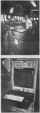
Naval forces operate in a tactical environment where data must be interpreted instantaneously and updated continuously. Naval vessels always have had to work around problems related to navigation accuracy and hostile, friendly, or unknown contacts. Gaining an ability to employ and defend against long-range antiship and land-attack cruise missiles has made solutions to these challenges more important than ever. To exploit the full cruise-missile potential, naval forces must be able to engage sea and land targets located over the horizon. This is feasible only if friendly, hostile, and neutral forces can be located precisely. In many cases, targeting data will be provided by other friendly units in the area, rather than by on-board sensors. In the past, ship defense depended on knowing an enemy's position relative to the vessel: e.g., "Captain, we have enemy aircraft inbound, bearing 220° at 20 nautical miles." To operate successfully in today's environment, positions of friendly and enemy forces must be known in terms of latitude and longitude. Course, speed, and time of position also must be known with a great degree of accuracy. The speed of battle requires real-time verification and distribution of this navigation information to human and machine users. Tremendous advances in information technology and fielding of the fully operational GPS offer an unprecedented opportunity to realize these demanding requirements. The Navigation Sensor System Interface (NAVSSI) collates, displays and disseminates all available own-ship navigation information on a common computer system. Using Navigation Satellite Timing and Ranging (NAVSTAR) GPS as its primary source of navigation data, the system provides real-time position, and displays historical information on watch station computer terminals. It also automates logs kept for navigation records. It was designed as an evolutionary, non-developmental acquisition program--an approach increasingly common for Navy information systems.
The U.S. Navy has designated NAVSSI as the standard shipboard electronic navigation system. It has completed operational evaluation, is in full rate production, and is being installed on surface combatants. In addition to integrating, displaying, storing, and logging navigational data, it sends the data to shipboard combat subsystems. Using the same computer rack as the Joint Maritime Command Information System (JMCIS) in combat information center (CIC), the ship's navigation team will be able to conduct navigation planning, monitor and select the most accurate navigation sensor, conduct mission planning, and use database management. Using all available navigation sensor inputs, NAVSSI determines ship position, course, speed, the location of the GPS satellites, and time. Depending on the platform, GPS, ship's inertial navigation system (SINS), electromagnetic (EM) speedlog, and Mk 19 gyrocompass, all provide inputs. In the future, the ring laser gyro navigator and Doppler sonar velocity log will replace the SINS and EM log. Other planned improvements include adapting it to accept inputs from radar, fathometer, and the aircraft carrier navigation system. System software ranks sensor inputs by timeliness and accuracy and selects the most accurate sensor available for each navigation parameter. If any sensor becomes unavailable for any reason, the system automatically selects the best source available. The ship's navigator can override automatic sensor selection and direct the system to use a specific sensor. The basic system displays the ship's position on a common video terminal. Updates provide real-time ship's movement to be displayed with an accuracy of 16 meters, if using the GPS Precise Positioning Service. Surface ship displays are located on the bridge and in the chart room; submarine displays will be in the control room. In addition, local area network users will be able to call up and view displays on their monitors. Notional JMCIS local area network ring requirements have been identified and will be included in the revised requirements document. The Defense Mapping Agency will begin issuing digital nautical charts over the next several years, and NAVSSI will be upgraded to display the appropriate digital chart as background; eventually, these digital charts will replace paper charts. The NAVSSI display will meet the International Maritime Organization and International Hydrographic Office specifications addressing display content, dimensions, resolution, and symbology. Digital charts will simplify certain navigation tasks considerably. Some capabilities exist today on the NAVSSI display using charts of the world. Chart updates and corrections in the future will consist of a CD-ROM containing the new data for loading into the system. Using NAVSSI, the navigation team and any other operator with access to the JMCIS network will be able to shift from one chart display to another by clicking a track ball. In addition to providing a visual position display, the system records inputs from the quartermaster of the watch, the gyrocompass or inertial navigation system, and GPS into a log database. The quartermaster then can collate and print pre-formatted ship's deck, position, compass, bearing, and--in the near future--fathometer logs. The system also puts out a continuous data stream for shipboard combat systems, e.g., GPS almanac data for Tomahawk Block IIIs. A similar interface will be available to output GPS data to the combat direction center to initialize standoff land attack missiles on aircraft carriers. The system will provide present position data to the Mk 86 gun fire control system, which requires such data to improve the accuracy of naval surface fire support and to process target coordinates sent in by land forces using the military grid reference system. The Tarawa (LHA-I)- and Wasp (LHD-l)-class amphibious assault ships will incorporate NAVSSI data into their advanced combat direction system. Conversions from grid to latitude-longitude and back again are prone to error when done manually, NAVSSI performs these conversions automatically, and will convert coordinates referenced to one datum to coordinates in another, eliminating one stumbling block to joint operations. Finally, the system will make piloting easier. Today, the CIC radar piloting team passes fix information to the quartermaster on the bridge by means of sound-powered telephones -- which can introduce errors. When the NAVSSI-radar interface is fielded, watch teams will be able to overlay radar and visual fixes electronically, comparing them to GPS positions on digital charts. Operators on the bridge and in CIC will see this information simultaneously and be able to make informed decisions. The system has three main subsystems in surface ships (two in submarines):
Training for both officers and enlisted personnel is being incorporated with other training curricula. Submarine training is still being set up, but surface warfare officers will find it included in various courses offered at Surface Warfare Officers School, Newport, Rhode Island. The Navigator/Senior Quartermaster Refresher courses at Fleet Training Centers in Norfolk, Virginia, and San Diego, California, and the Afloat Training Group, Pearl Harbor, Hawaii, and Yokosuka, Japan, also will include NAVSSI. Enlisted training will be incorporated at the Quartermaster "A" School, Great Lakes, Illinois; Navy Tactical Command System-Afloat (NTCSA) Operator schools, Fleet Combat Training Center Atlantic and Pacific in Dam Neck, Virginia, and San Diego; Senior Quartermaster Refresher and Celestial Refresher courses at Norfolk and San Diego; and JMCIS Maintenance Technician courses. Mariners have sought the highest degree of navigational accuracy for centuries -- and today's equipment has brought it within reach. This is particularly true for naval combat and command-and-control systems. NAVSSI provides automated distribution of standardized navigation and time data to watch standers and combat systems and subsystems. It supports a common picture via an open architecture for easy integration and upgrade capability with other communications, information support, and weapon systems. Lieutenant O'Connor and Senior Chief Kabrick are instructors at the Surface Warfare Officers School Command in Newport. Rhode Island. Mr. Truver is the NAVSSI Deputy Assistant Program Manager at the Space and Naval Warfare Systems Command, Arlington, Virginia.
|
| HOME | Articles | Sea Stories | Book List |
| Links | Deck Log | Contribute | About |
 Back to Articles page